Jump directly to page content
Stiftung Wissenschaft und Politik
Stiftung Wissenschaft und Politik Logo
swp_logo_en
Toggle navigation
Search
Search suggestions appear when at least 2 characters are entered. Use the arrow keys to navigate through the suggestions.
Submit search
Contact
Career
Media
DE
Deutsch
EN
English
Search
Search suggestions appear when at least 2 characters are entered. Use the arrow keys to navigate through the suggestions.
Submit search
Topics
Topics
close navigation
Overview: Topics
Research Areas
Research Areas
Sub-Saharan Africa
Asia
Digitalisation, cyber, technology
Energy, climate, environment
EU, Europe
Latin America and the Caribbean
Migration, development cooperation
Non-state violence
North Africa and Middle East
Russia, E. Europe, Central Asia
Security and defence policy
Turkey
UN, global governance, int. law
USA, Canada
Economics, trade, resources
Thematic Working Groups
Thematic Working Groups
International cooperation in the context of systemic rivalry
Reordering European security
The challenge of autocratisation
Economic and technological transformations
Dossiers
Dossiers
Cybersecurity and Digital Policy: The Role of the Digital in International Politics
The US and Transatlantic Relations
Energy Policy
European elections 2024 and the EU's next strategic agenda
Forced Displacement and Migration
Climate Policy and Politics
Russia's war against Ukraine and its consequences
United Nations and Sustainable Development
In Focus
In Focus
War in the Middle East
Publications
Researchers
About SWP
About SWP
close navigation
Overview: About SWP
About SWP
About SWP
Team A-Z
Organization
Fundamentals
Friends and Partners
Research
Research
Research Divisions
Horizontal Topics Working Groups
Centre for Applied Turkey Studies (CATS)
Megatrends Afrika project
SWP research projects
Research clusters
Research guidelines
Service
Service
close navigation
Overview: Service
Consulting Services
Newsletter
SWP Podcast
WebMonitors
Bibliographic Database
Social Media
RSS feed
Contact
Career
Media
DE
Deutsch
EN
English
Stiftung Wissenschaft und Politik
Topics
Dossiers
Cybersecurity and Digital Policy: The Role of the Digital in International Politics
Further readings
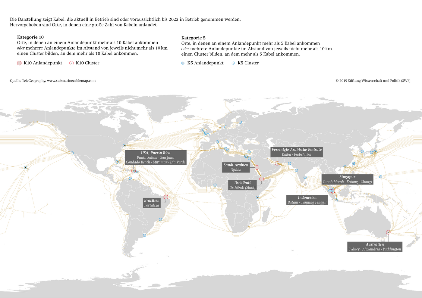
Safety and Availability of Submarine Cables
Dossier Overview
Concentration of landing points in the worldwide network of submarine cables